Wallaman Falls is located in northern Queensland, 51 km south-west of Ingham. Wallaman Falls is part of the traditional lands of the Warragamaygan Aboriginal people. It is part of the Wet Tropics Heritage Area, which is home to some of the oldest rainforests on earth and many endangered plants and animals.
Wallaman Falls is situated within the Girringun National Park which descends from Atherton Tableland. It’s watercourse is the Stony Creek. Wallaman Falls is the highest, permanent single-drop waterfall in Australia, with a total height 305 metres. It has two drops, and the longest drop is 268 metres. The width of Wallaman Falls is 15 metres wide and its elevation is between 533 and 554 metres. Wallaman Falls also has a pool at the bottom of it which is 20 metres deep. It was formed by major geological events. About 50 million years ago, the Earth’s crust formed the edge of the continent that lies against the Coral Sea and Wallaman Falls began to form. Herbert River flowed towards the west but it is not known when it reached the flowing course Wallaman Falls is on. The erosion continued, causing the Herbert River Falls to retreat constantly. As the gorge became longer, it passed tributaries including Stony Creek, which were then suspended. This created waterfalls, such as Wallaman, which in turn eroded their own gorges.
Wallaman Falls is situated within the Girringun National Park which descends from Atherton Tableland. It’s watercourse is the Stony Creek. Wallaman Falls is the highest, permanent single-drop waterfall in Australia, with a total height 305 metres. It has two drops, and the longest drop is 268 metres. The width of Wallaman Falls is 15 metres wide and its elevation is between 533 and 554 metres. Wallaman Falls also has a pool at the bottom of it which is 20 metres deep. It was formed by major geological events. About 50 million years ago, the Earth’s crust formed the edge of the continent that lies against the Coral Sea and Wallaman Falls began to form. Herbert River flowed towards the west but it is not known when it reached the flowing course Wallaman Falls is on. The erosion continued, causing the Herbert River Falls to retreat constantly. As the gorge became longer, it passed tributaries including Stony Creek, which were then suspended. This created waterfalls, such as Wallaman, which in turn eroded their own gorges.
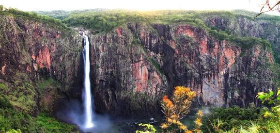
Wallaman Falls in northern Queensland
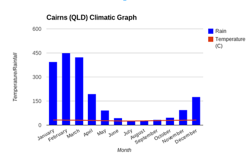
Climatic Graph for Cairns/Wallaman Falls
Cairns is situated at the top of Queensland, on the east coast of the Cape York Peninsula. Cairns is near Wallaman Falls, which is one of the Queensland landforms I chose to do. It lies in the climatic region of being tropical or mid-latitude. This means that Cairns experiences hot and humid weather but a fair bit of rainfall, especially in the summer months.
Cairn’s temperature throughout the year, according to my graph and data, only varies from approximately 32°C and 25°C. This is only a 7° difference. The hottest months in Cairns are January, February and December (the summer months) with an average temperature of about 31°C. Cairns has an abundance of rainfall throughout the year, with a total of 2007.9mm. February has the most rainfall with an average of 450 mm. July and August have the least amount of rainfall with only about 25-30mm on average.
Cairn’s temperature throughout the year, according to my graph and data, only varies from approximately 32°C and 25°C. This is only a 7° difference. The hottest months in Cairns are January, February and December (the summer months) with an average temperature of about 31°C. Cairns has an abundance of rainfall throughout the year, with a total of 2007.9mm. February has the most rainfall with an average of 450 mm. July and August have the least amount of rainfall with only about 25-30mm on average.
