The Bungle Bungle Ranges is located in the north-west of Western Australia, in the Kimberley's. It is in the World Heritage-listed, Purnululu National Park. These Ranges are situated east off Highway 1 between Kununurra in the north and Halls Creek in the south.
The national park stretches over 2397 square kilometres and the Bungle Bungle Ranges takes up about 450 square kilometres. It takes up a vastly large area of this national park.
The Bungle Bungle Ranges is known to have formed about 350 million years ago. The Bungle Bungle Ranges is not part of a reef, but it is sediment of an old river. The sediment was laid down in layers, compressed into sandstone and eventually lifted up to form a mountain range. Originally, it was all one big block, with a few weak areas and cracks. Over time, the cracks got worse with erosion, and as a result, it moved. More weathering happened, causing more cracks and the edges wore away in the millions of years of wet season, rainfall, wind, which also combined with winters freezing and over 50 degree summers.
The darker layers of the rock are clay, which hold the moisture better. The lighter layers have less clay and dry out quickly. The sandstone at these Ranges are very soft and fragile. The waters in the wet season have washed out wide creeks and deep canyons.
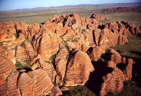
Bungle Bungle Ranges in the north-west of Australia, in the Kimberley's.
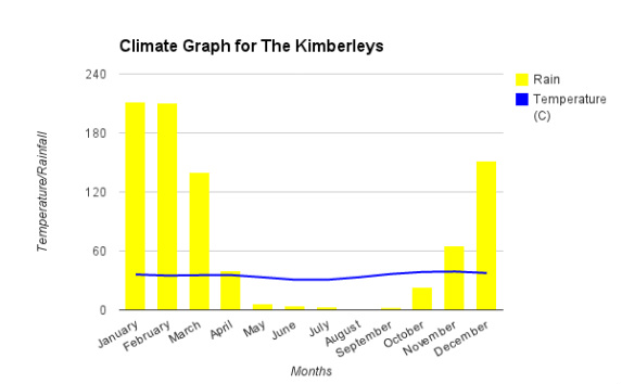
Climatic Graph for The Kimberleys/Bungle Bungle Ranges
The Kimberleys are located at the northern end of Western Australia, and is one of nine regions in this large state. Within the Kimberleys, is the Bungle Bungle Ranges, which is also one of the landforms I chose to research. To the east of the Kimberleys is the Northern Territory, to the west is the Indian Ocean, north of the Kimberleys is the Timor Sea and below, to the south is The Great Sandy Desert and Tanami Desert.
The Kimberleys lies in the tropical monsoon climatic region. This means they receive about 90% of rainfall during their short wet season, but is one of the hottest parts of Australia. The temperature in The Kimberleys does not vary throughout the year, as shown on the graph above. The hottest month in the Kimberleys is November, with an average monthly temperature of 39.1 degrees. The lowest months are June and July, both with averages of 30.7 degrees. This is only an 8.4 degree difference between the hottest and coolest months throughout the year, which demonstrates the weather being consistently humid.
The rainfall in the Kimberleys is opposite to the temperature, being very inconsistent. The wettest months throughout the year are January and February with 211.3mm and 210.3mm. Throughout the middle of the year (May, June, July, August and September), the Kimberleys have very little rainfall with a total of just 16.5mm during these five months. This shows that these months are the driest throughout the year. In the Kimberleys, they have an annual total of 812.5mm of rainfall.
