The Glasshouse Mountains are located in south east Queensland, about an hours drive (or 70 km) north of Brisbane. They are a group of eleven hills that rise from the coastal plain in Queensland’s Sunshine Coast hinterland.
These rough and uneven volcanic peaks tower above the neighbouring landscape and are very significant, hence the reason for being listed on the Queensland and National Heritage Register as a landscape of national significance.
The most identifiable mountain is Mount Tibrogargan because it looks like a giant ape sitting by the roadside, looking out to sea.
These set of eleven mountains range from different heights of 123m to 556m, which rise from the flat coastal plain. The Glasshouse Mountains stretch over 9.2 square kilometers.
The Glasshouse Mountains were formed when molten rocks filled the small vents, or intruded as bodies beneath the surface, which then cooled to form hard rock in the cores of volcanoes between 26-27 million years ago. The surrounding rocks have been eroded throughout time, forming the amazing volcanic plugs that are there today. As the volcanic mountains cooled, interesting vertical columns formed at Mount Beerwah, Mount Ngungun and Mount Coonowrin.
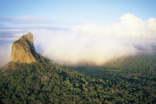
Glasshouse Mountains in Queenslands south east.
Climatic Graph for Brisbane/Glasshouse Mountains
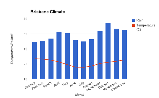
Brisbane is the capital city of Queensland, and is located in the south-eastern corner of the state, to the east of The Great Dividing Range. It is near one of the landforms I chose to do, which is The Glasshouse Mountains. Brisbane lies in the climatic region of being humid subtropical. This means Brisbane has humid summers and mild winters. The humid subtropical climatic zone covers half of Australia's east, which suggests why Queensland is dominated by this climatic region.
The temperature throughout the year in Brisbane does not vary very much. This is shown in my graph, which tells us that January is the hottest month, having an average maximum temperature of 30.3 degrees and the coldest being 21.8 degrees. This is only a difference of 8.5 degrees throughout the whole year.
Brisbane has a consistent amount of rainfall throughout the year with each month having a decent amount of rainfall. The wettest months during the year are October and November, with rainfall averages of 60.3 degrees to 66.2 degrees. The driest months are not much less, with them being January and July, having averages between 47 and 48 degrees.
